
I know I’ve talked about preparing for a hurricane, so if you need a brush up on that, here is the link to the blog post about perishables and supplies:
Get Your Hurricane Map
Download your hurricane map here:
https://www.floridadisaster.org/globalassets/importedpdfs/hurrtrackmap.pdf
This map includes all the coordinates from 50°W to 100°W and 12°N to 35°N, which is not enough room for full tracking, but gives you enough space to chart things you need to worry about.
Map Coordinates
As you can tell, the map is broken up into degrees from east to west and north to south. Since the majority of the hurricanes and action start off the coast of Africa, the 50-degree mark west is too close to home to see the activity.
The NOAA map is bigger and takes us to the edge of Africa and north to Newfoundland, Canada. This is my preferred map because I am a geek that likes to draw little lines on a piece of paper. The map coordinates are tiny, so if it’s an active season, it will get all squiggled up quickly.
While the local newspapers and television will let you know when there is a storm headed your way, if you take the time to check with NOAA during the season, you can start planning a lot further into the future. I have been surprised by a hurricane or two – mostly because I was still without power from the first one that hit me to know there was another one –, so I prefer to watch them as they develop.
As you can see from this NOAA hurricane map, there is a small disturbance by Belize that has less than a 40% chance of development. The hurricane map has the legend at the bottom, so you can interpret the symbols. The maps are updated, along with 2-day outlooks regularly, so if you’re watching the storms, you first choice should be the NOAA site at
https://www.nhc.noaa.gov/cyclones/ for us in Florida or on the East Coast.

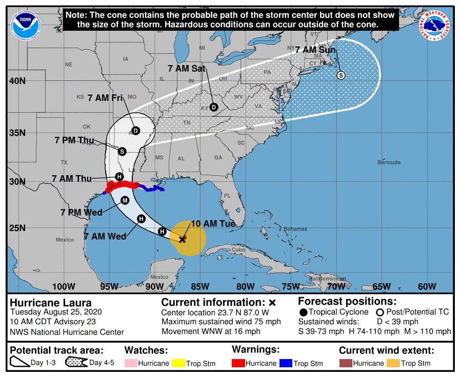
Cone of Uncertainty
Let’s talk about the so-called Cone of Uncertainty, as the media likes to call it. When there is a storm that is predicted to develop, meteorologists begin to use modeling services that can help them predict where the storm is headed.
If you stay in Florida long enough, you’ll understand that they are wrong way more times than they are right. In their wrongness people freak out and do all kinds of dumb things like hoard peanut butter because apparently that is the only food source known to man that can keep us safe. Or buy 50 cents worth of gas at a time to keep their tanks ‘topped off’ in case they have to drive to Alaska to escape. They will wait in line for 4 hours to put in a quarter of a gallon. Panic does no one any good. But, you have a map, so you are not panicking.
Charting Hurricane Map Extreme Paths
When they show the path of the hurricane, the cone represents the extreme paths on either side that the storm could take. It doesn’t mean that the storm will stay in the center and that is the maximum width the storm will have. Anytime within the storm’s development stage, that center can move.
The other thing to remember is that when the center moves, so does the outer bands of the storm. Just because the center is in one place doesn’t mean that you won’t be affected. Storms are wide and carry a lot of wind and rain with them. As they spin, that wind and rain peels off and affects areas far from their center. So, if you see the Cone of Uncertainty and you’re on the outside of the furthest edge of the cone, you’re going to need to protect yourself from the outer bands of the storm. A hurricane is shaped like a buzz saw, and like buzz saws, there are a lot of sharp edges that will cut through the atmosphere.
This graphic from NOAA shows how the cone can be as narrow as going up the center of Florida to as wide as missing Florida altogether on either side.

Category Descriptions
Tropical Wave – It all starts with the wave. It is an area of low pressure that is moving off of the coast of Africa and into the Atlantic Ocean. This wave can form a tropical cyclone.
Tropical Cyclone – An organized and rotating system of thunderstorms that form over warm, tropical and subtropical waters. In the Norther Hemisphere they spin counterclockwise. If they form at the 5 to 30 degree mark in the North latitude, then they usually move westerly. If they form or reach the 30 degree mark, they usually turn northeast. Wind shifts within the storm can alter the latitude, so watch for changes.
Tropical Depression – Once a cyclone has reached top sustained winds of 38 MPH or less, it is considered a depression. You will see surfers watching this because it will create swells that are great for surfing. Check out the Cocoa Beach surf report on Surfguru.com if you need more surf information.
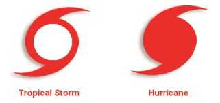
Tropical Storm – Once the depression hits a sustained wind of 39 to 73 MPH, it is considered a storm. If this strengthens, it will become a hurricane. Wind and rain can be expected if you are in the path of a tropical storm. The damage is usually minor, but limbs and loose objects in the yard can go flying. There may be flooding.
Hurricane Ratings
Hurricanes are rated based on the Saffir-Simpson Hurricane Wind Scale that is used to estimate property damage. No matter the category or strength, there are always risks to life and property due to storm surges, blowing objects, power lines and flooding.
Hurricane: Category 1 – 74-95 MPH sustained winds can cause property damage. Most Florida structures are built to the Miami-Dade Hurricane Code that ensures the structures are strapped down. This code was updated after Hurricane Andrew. Roof damage is possible with shingles being the first to go. There can be power outages.
Hurricane: Category 2 – 96-110 MPH sustained winds that are dangerous to property and people. Frame homes can have major roof damage. Trees can be uprooted and roads can be blocked. Power may be out for a few days to weeks.
Hurricane: Category 3 – 111-129 MPH sustained winds are devastating to an area. There can be major damage even to the most well-constructed house. Roof damage is probable, as is damage to decks, siding and windows that are not covered. Expect power to be out for weeks after a storm like this.
Hurricane: Category 4 – 130-156 MPH sustained winds cause catastrophic damage to even the best built buildings and homes. Trees will be snapped and uprooted, and there will be no power. Areas hit by a Cat 4 will not have power for possibly months, and there is a good chance it will be uninhabitable.
Hurricane: Category 5 – 157-higher MPH sustained winds will flatten the area and completely destroy all structures. The trees will be gone, and the power may not be restored for months. It will be uninhabitable indefinitely.
Hurricane Map Symbols
I apologize for the length of this post, but since the hurricane season is ramping up, I thought I should get this out now.
Season runs from June 1 – December 1, but the tropics never to seem to get that memo, so it’s not unusual to see storms in May or late December. I have been in Cat 2 and low Cat 3 storms, so if you are told to evacuate, get on the road as soon as they tell you to go.
Roads in Florida are limited. You do not want to be stuck on I-95 with a storm bearing down, so make your plans early – like long before there is a storm – like now as to where you will go and how you will get there.
Shelters fill up, and sometimes you cannot take your pets. DO NOT leave your pets to ride the storm out, so figure out how to save yourself and your family.
Chances are you’ll never have to leave, but if you do, be prepared to evacuate.
Here are some things you might want to buy ahead of time for your hurricane survival kit:


If you liked this post, please share it with your friends! I love comments, so tell me what you think below.
